Just east of Algiers lies a breathtaking mountainous region along the northern coast of Algeria. It is amongst the rolling green hills and diverse landscape that Djemila can be found. The scattered remains of the Roman Empire that once ruled this expanse is the only memory of their occupation, yet stands as a monument to their engineering skills in constructing a beautiful town on a landscape that few would choose for construction. All though Djemila was not a big town, and therefore not the largest ruins in North Africa, it is the best preserved and can be described as extraordinary.

Djemila was constructed during the first century AD under the name of Cuicul. It began its existence as a military garrison, but the occupiers soon realized that the agriculturally rich landscape could be used to farm. Farming and agricultural products such as olives and cereal transformed Cuicul into a thriving market place. After the fall of the mighty Roman Empire, the town of Cuicul was slowly abandoned during the fifth century. Even thought the Muslims took over the region, they did not settle into the town. They merely renamed it to Djemila, meaning beautiful, and left the town to fade into memory and oblivion until excavation work started on it in the year 1909.

It is believed that during the third century there were approximately twenty thousand people occupying the city. The museum at the entrance of the ruins has a magnificent collection of artifacts, such as mosaics, marble statues, cooking utensils and items, oil lamps and other reminders of their lives. So many items were recovered from the site that it seems as if the museum can barely contain them. The ruins themselves are magnificent. A basilica and a baptistery were dated back to the fourth century and while the buildings contain the original mosaics, the dome has been restored. The eighteen roomed Europe House is built with a courtyard in its centre and the Great Baths have remained in surprisingly good condition, with double panels and pipes, where hot water once ran, being seen intermittently. Other constructions of interest and splendor include the triumphant arch, the theatre which is able to accommodate three thousand spectators, the temples and the third century altar.


Original Post: algeria


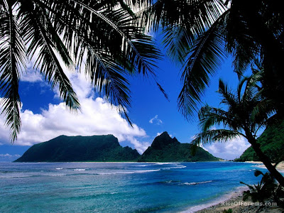
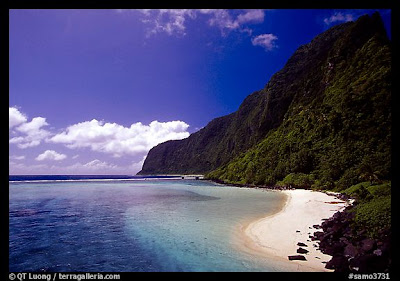
The airstrip is by a white beach on the south side of Ofu, about an hour's walk from Olosega village, and it's still possible to have to yourself this quintessential Polynesian paradise of swaying palms, magnificent reef, and rugged mountains rising out of the sea. The beach and reef between the airstrip and the bridge are now part of National Park of American Samoa. Flying foxes are common along the south coast in the late afternoon.

To climb to the former television tower atop Ofu's Tumutumu Mountain (494 meters), take the concrete ramp up the hill from near the wharf at Alaufau village and keep straight ahead for five km on a track cut by a bulldozer decades ago. It's not hard to follow if you avoid turns and descents. Continue up to the ridge top, then over the well wooded mountain to Leolo Ridge (458 meters). There's ample shade in the morning when the sun is still on an angle. The best views are obstructed by trees.

Olosega Sights

For Olosega's Piumafua Mountain, follow the road through the village south almost to Maga Point, then cut back up along the ridge to the 639-meter summit. Unfortunately, the route is now completely overgrown and only practical with a local guide able to chop a way forward. The cloud forest atop the steep hill after you think you've hit the peak is like the Old Forest in The Lord of the Rings. No goblins—only mosquitoes—but be very careful not to get turned around, as the trees cut off the view, and it's easy to get lost.This is one of Manu'a's best bird-watching trips, with nesting boobies on the point and ground-doves in the lower forest.

There's no trail along Olosega's forbidding east coast.


Original Post: americansamoa


The Kasbah of Algiers was founded on the ruins of old Icosium, a Phoenician commercial outpost called which later developed into a small Roman town. It is a small city which, built on a hill, goes down towards the sea, divided in two: the High city and the Low city.

One finds there masonries and mosques of the 17th century; Ketchaoua mosque (built in 1794 by the Dey Baba Hassan) flanked by two minarets, mosque el Djedid (built in 1660, at the time of Turkish regency) with its large finished ovoid cupola points some and its four coupolettes, mosque El Kébir, mosque Ali Betchnin, Dar Aziza, palate of Jénina. In the Kasbah, there are also labyrinths of lanes and houses that are very picturesque.


Original Post: worldheritagesite

In 1982, UNESCO recognized the M’Zab Valley as a World Heritage Site, not only because of its beauty, but the significance of the towns and villages that are located within this region of Algeria. The towns have adapted to suit their environment, while using traditional and ingenious methods to create environmentally friendly structures that blend into the landscapes of the M’Zab Valley. Situated approximately five hundred kilometers outside of Algiers, the M’Zab Valley can be found in the Northern Saharan region of the country.

The historical presence of ancient tribes can be seen through out the valley as symbols adorn various rocks and features in the valley. The walled villages in the M’Zab Valley each have their own unique structures that serve as attractions to their settlement, much as mosques, minaret towers or the layout of the homes, which are usually constructed to circle the mosque. Many of them serve as a welcoming oasis to travelers, with breathtaking palm groves supplying a cool place to rest, and a living to the residents of the village. As the valley provides fertile land for the towns to plant their palm plantations, it is a picturesque region, from start to finish. Tradesmen and souvenir shop owners are very convincing and tourists will often end up buying a few more items then intended. Visiting the M’Zab Valley is a rewarding and memorable region, where locals are friendly and sights are awe inspiring.


Original Post: algeria


The Statue of Christ the Redeemer history starts in the XVIth Century when the Portuguese named the mountain Pináculo da Tentação (The Pinnacle [peak] of Temptation), alluding to the Biblical Mountain.


Original Post: copacabana


Khyber Pass is perhaps the most famous pass in the world because of its geographic as well as historic importance. Going northwest from the eastern end in Pakistan, the pass starts from near Jamrud and ends west of Torkham, Afghanistan, a winding road. The route passes Fort Maude and Ali Masjid to reach the narrowest point of the pass. The summit is at Landi Kotal, followed by a steep decline to Michni Kandao, Landi Khana and the Afghan border just east of Torkham. Here the gradient becomes easier as the pass exits at Haft Chah onto the Dakka plain. From Dakka, the Kabul River flows back to Peshawar through the Loe Shilman Gorge, a less direct and more difficult route, but the one chosen by Alexander the Great when he crossed over into India in 326 BCE.Jamrud is at an elevation of 491 m, while the summit at Landi Kotal is 1070 m. A road was built by the British through the Pass in 1879 and a railroad in the 1920s.Khyber pass is a narrow, steep-sided pass, 28 mi long, winding through the Safed Koh Mts., on the Pakistan-Afghanistan border; highest point is 3,500 ft. The routes through it link the cities of Peshawar, Pakistan, and Kabul, Afghanistan. For centuries a trade and invasion route from central Asia, the Khyber Pass was one of the principal approaches of the armies of Alexander the Great, Timur, Babur, Mahmud of Ghazna, and Nadir Shah in their invasions of India. The pass was also important in the Afghan Wars fought by the British in the 19th cent. The Khyber Pass is now traversed by an asphalt road and an old caravan route. A railroad, which passes through 34 tunnels and over 92 bridges and culverts, runs to the Afghan border. Pakistan controls the entire pass.

You may travel by road from Peshawar via Jamrud fort which lies amongst low story hills capped with pickets manned by Khyber Rifles. Also on the way you will see Ali Masjid and the fort with insignia of the regiments that have served in the Khyber. On route is also the Sphola stupa of Buddhist period (2-5 centuries A-D) and Landikotal Bazaar until you reach the border post at Torkham.

For rail enthusiasts, there is also a Khyber railway. It threads its way through 34 tunnels crossing 92 bridges and culverts and climbing 1,200 metres. The British built it in 1920 at an enormous cost of Rs. Two million. Two or three coaches are pulled and pushed by two 1920 model steam engines. At one point, the track climbs 130 metres in less than a mile by means of the famous Changai Spur, a section of track shaped like a "W" with two reversing stations.


Original Post: world66


The Colosseum - the greatest amphitheatre of the antiquity - was built in Rome, Italy, about 1920 years ago. It is considered an architectural and engineering wonder, and remains as a standing proof of both the grandeur and the cruelty of the Roman world.

After the splendour of imperial times, the Colosseum was abandoned, and in turn it became a fortress for the medieval clans of the city, a source of building materials, a picturesque scenery for painters, a place of Christian worship. Today it is a challenge for the archaeologists and a scenario for events and shows.In this site you'll find information on history, architecture and on the games that were held in the amphitheatre, there are also news on the events in the Colosseum, practical information for a visit, FAQs, a page of feedback with the most usual questions asked by our readers, and much more, like figures and plans,a sitemap and even a page on the cats of the arena.

Please read this disclaimer: those of you who know about the Roman amphitheatre are kindly requested to do no more than smile at my efforts on these pages, and write me to correct it if you feel so inclined; those of you who come to the subject for the first time should certainly not take my opinions as gospel.


Original Post: the-colosseum

7,000 feet above sea level and nestled on a small hilltop between the Andean Mountain Range, the majestic city soars above the Urabamba Valley below. The Incan built structure has been deemed the “Lost Cities”, unknown until its relatively recent discovery in 1911.

Archaeologists estimate that approximately 1200 people could have lived in the area, though many theorize it was most likely a retreat for Incan rulers. Due to it’s isolation from the rest of Peru, living in the area full time would require traveling great distances just to reach the nearest village. Separated into three areas - agricultural, urban, and religious - the structures are arranged so that the function of the buildings matches the form of their surroundings. The agricultural terracing and aqueducts take advantage of the natural slopes; the lower areas contain buildings occupied by farmers and teachers, and the most important religious areas are located at the crest of the hill, overlooking the lush Urubamba Valley thousands of feet below. Hikers, tourists, and the early explorers describe similar emotions as they climb their way through the Inca Trail. Many call the experience magical.

Glancing out from the Funerary Rock Hut on all the temples, fields, terraces, and baths seems to take you to another time. Blending in with the hillside itself, many say the area creates a seamless and elegant green paradise, making it a must for anyone who travels to Peru.


Original Post: peru-machu-picchu


The Great Wall of China is a series of stone and earthen fortifications in , built, rebuilt, and maintained between the 5th century BC and the 16th century to protect the northern borders of the Chinese Empire during the rule of successive dynasties. Several walls, referred to as the Great Wall of China , were built since the 5th century BC. The most famous is the wall built between 220 BC and 200 BC by the first Emperor of China, Qin Shi Huang; little of it remains; it was much farther north than the current wall, which was built during the Ming Dynasty.

Original Post: greatwall-of-china


The stones we see today represent Stonehenge in ruin. Many of the original stones have fallen or been removed by previous generations for home construction or road repair. There has been serious damage to some of the smaller bluestones resulting from close visitor contact (prohibited since 1978) and the prehistoric carvings on the larger sarsen stones show signs of significant wear.

In its day, the construction of Stonehenge was an impressive engineering feat, requiring commitment, time and vast amounts of manual labor. In its first phase, Stonehenge was a large earthwork; a bank and ditch arrangement called a henge, constructed approximately 5,000 years ago. It is believed that the ditch was dug with tools made from the antlers of red deer and, possibly, wood. The underlying chalk was loosened with picks and shoveled with the shoulderblades of cattle. It was then loaded into baskets and carried away. Modern experiments have shown that these tools were more than equal to the great task of earth digging and moving.


Original Post: britannia

The giant red mountains and vast mausoleums of a departed race have nothing in common with modern civilization, and ask nothing of it except to be appreciated at their true value - as one of the greatest wonders ever wrought by Nature and Man.

Although much has been written about Petra, nothing really prepares you for this amazing place. It has to be seen to be believed.

Petra the world wonder, is without doubt Jordan’s most valuable treasure and greatest tourist attraction. It is a vast, unique city, carved into the sheer rock face by the Nabataeans, an industrious Arab people who settled here more than 2000 years ago, turning it into an important junction for the silk, spice and other trade routes that linked China, India and southern Arabia with Egypt, Syria, Greece and Rome.Entrance to the city is through the Siq, a narrow gorge, over 1 kilometre in length, which is flanked on either side by soaring, 80 metres high cliffs. Just walking through the Siq is an experience in itself. The colours and formations of the rocks are dazzling. As you reach the end of the Siq you will catch your first glimpse of Al-Khazneh (Treasury).

This is an awe-inspiring experience. A massive façade, 30m wide and 43m high, carved out of the sheer, dusky pink, rock-face and dwarfing everything around it. It was carved in the early 1st century as the tomb of an important Nabataean king and represents the engineering genius of these ancient people.


Original Post: visitjordan

Kabul has existed for some 3,500 years. It is mentioned in the Rigveda (collection of Indian sacred hymns; c. 1500 bc), and Ptolemy, the Alexandrian astronomer, geographer, and mathematician, knew of it in the 2nd century ad. The city owes its long preeminence to its location commanding the passes from the north through the mountains of the Hindu Kush and from the south through the towns of Ghaznī and Gardeyz (Gardēz). It also commands the main approaches through the Khyber Pass to Pakistan and India. Kabul first became a regional seat of government in the 8th century. In the 13th century the Mongol invader Genghis Khan inflicted considerable damage on the city. Kabul was the capital (1504–26) of the Mughal dynasty, under Bābur, and it remained under Mughal rule until 1738, when Nādir Shah of Iran took it.

Kabul has been the capital of Afghanistan since 1776; during the First Anglo-Afghan War, British garrisons were massacred there (1842). It was the centre of much military and guerrilla activity after the outbreak of the Afghan War in 1978. The Soviet Union invaded Afghanistan in 1979 in an effort to shore up a Marxist regime there; the invasion started when the Soviet Union began a large-scale airlift of combat troops into Kabul city. Early in 1980 a Soviet military command was established in Kabul and the airport was improved. Following the Soviet withdrawal from Afghanistan in 1989, internecine fighting between the Afghan guerrillas continued intermittently in the city and surrounding areas. By 1996, when the Taliban militia took control of Kabul, the city lay in ruins. The Taliban did little to rebuild it or repair its infrastructure and fled in advance of a coalition of Afghan and U.S.-led forces in 2001. The city remained the capital under an interim government.


Kabul is a blend of old and new buildings. Much of the old city has been torn down and rebuilt on modern lines. Kabul has many historical monuments, including the tombs of some of its rulers, and a number of gardens. Bābur’s garden, including his tomb, is near the western extremity of the old city at the base of the Sherdawaza. The Dār ol-Amān palace houses the parliament and government departments. The University of Kabul was founded in 1932. Many of these institutions, however, suffered damage during the civil war. The city’s industries include food-processing plants, rayon and wool mills, a furniture factory, a foundry, and a marble works. Kabul’s population is mainly Persian- (Dari-) speaking, although there is a large proportion of Pashtuns. Pop. (2006 est.) city, 2,536,300; metro. area, 3,138,100.


Original Post: britannica


Taj Mahal was built by a Muslim, Emperor Shah Jahan (died 1666 C.E.) in the memory of his dear wife and queen Mumtaz Mahal at Agra, India. It is an "elegy in marble" or some say an expression of a "dream." Taj Mahal (meaning Crown Palace) is a Mausoleum that houses the grave of queen Mumtaz Mahal at the lower chamber. The grave of Shah Jahan was added to it later. The queen’s real name was Arjumand Banu. In the tradition of the Mughals, important ladies of the royal family were given another name at their marriage or at some other significant event in their lives, and that new name was commonly used by the public. Shah Jahan's real name was Shahab-ud-din, and he was known as Prince Khurram before ascending to the throne in 1628.

Taj Mahal was constructed over a period of twenty-two years, employing twenty thousand workers. It was completed in 1648 C.E. at a cost of 32 Million Rupees. The construction documents show that its master architect was Ustad ‘Isa, the renowned Islamic architect of his time. The documents contain names of those employed and the inventory of construction materials and their origin. Expert craftsmen from Delhi, Qannauj, Lahore, and Multan were employed. In addition, many renowned Muslim craftsmen from Baghdad, Shiraz and Bukhara worked on many specialized tasks.

The Taj stands on a raised, square platform (186 x 186 feet) with its four corners truncated, forming an unequal octagon. The architectural design uses the interlocking arabesque concept, in which each element stands on its own and perfectly integrates with the main structure. It uses the principles of self-replicating geometry and a symmetry of architectural elements.

Its central dome is fifty-eight feet in diameter and rises to a height of 213 feet. It is flanked by four subsidiary domed chambers. The four graceful, slender minarets are 162.5 feet each. The entire mausoleum (inside as well as outside) is decorated with inlaid design of flowers and calligraphy using precious gems such as agate and jasper. The main archways, chiseled with passages from the Holy Qur’an and the bold scroll work of flowery pattern, give a captivating charm to its beauty. The central domed chamber and four adjoining chambers include many walls and panels of Islamic decoration.

The mausoleum is a part of a vast complex comprising of a main gateway, an elaborate garden, a mosque (to the left), a guest house (to the right), and several other palatial buildings. The Taj is at the farthest end of this complex, with the river Jamuna behind it. The large garden contains four reflecting pools dividing it at the center. Each of these four sections is further subdivided into four sections and then each into yet another four sections. Like the Taj, the garden elements serve like Arabesque, standing on their own and also constituting the whole.


Original Post: islamicity

About this blog